Browse My
Featured Learning Activities

Reflections on My GIS Journey
As my time with the my introductory course to Geographic Information Science, comes to a close, here is a reflection of my experience with GIS and some skills I acquired along the way.

Anthropogenic Impacts on Southern Resident Killer Whales: Implications for Conservation Strategies
Southern Resident Killer Whales (SRKW) are a cultural icon of British Columbia with only 74 left alive. For our final project, my team and I analyzed the three major threats to SRKW - lack of prey availability, vessel disturbances, and pollution. We hope that our analysis highlights the impacts of these disruptions, while encouraging adequate conservation strategies for the rehabilitation of our beloved orcas.
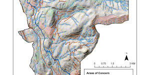
Environmental Impact Assessments with GIS: Understanding Implications of the Garibaldi at Squamish Project
The Garibaldi at Squamish project is a proposed all-year mountain resort on Brohm Ridge, 15 km north of Squamish on Highway 99. The project has been tentatively approved with 900 construction jobs and 2500 operative jobs to be made in the process. However, the making and manning of this resort will come at a cost of the area's environmental integrity. In this assignment, I have been tasked with performing an environmental impact assessment of the proposed project and its implications.
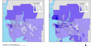
Visualizing Housing Affodability: Trends and Classification Implications
Despite being one of the most liveable cities in the world, Vancouver is also one of the least affordable. As a (pseudo) data journalist, I have been tasked to compile maps to accompany an article on housing costs in Vancouver. In this assignment, I explored the different classification methods when displaying data and how this may be governed by personal bias, agency disposition, and the intended message or purpose that underlies data representation.
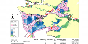
Climate Change & Coastal Cities: Planning for a Storm Surge
I love Vancouver, but climate change poses serious threats, such as increased potentials of storm surges, to coastal cities like my own. Insight of these impending challenges, I have been tasked to map out areas at risk in the Greater Vancouver region. Using spatial analysis, map layout and editing tools, I created four maps showcasing the low-lying areas, flood-prone areas and major routes that would be jeopardized in the case of a storm surge.